
Geographic Information Science (GIS) is very much in demand and used in many fields such as law enforcement, urban planning, health, conservation and many more. There are endless career paths for GIS majors or students in another program who have some GIS background. While some of our alumni majored in GIS at BMCC, others pursued this area after graduating. The GIS major is relatively new–some of our alumni graduated before it existed, but still found their way into this exciting field. It is easier today for students wishing to pursue GIS, as BMCC offers this major and is, in fact, the only CUNY community college with this program.
Read about some of the paths taken by BMCC alumni who work in this field.
Learn more about our Geographic Information Science (GIS) program.
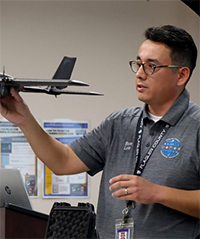
Bruno Luna
Academic Background: A.S. Geographic Information Science (GIS), BMCC (2019)
Update: I am currently working as the Unmanned Aerial Systems (UAS) Program Coordinator for Flagler County, Florida. One of my key responsibilities in my current role as UAS Program Coordinator is to monitor the safe integration of unmanned aerial systems while supporting various types of missions. Though my position isn’t specifically GIS focused, I still get to work with our GIS department for mapping purposes, as well as many other departments who need drone work. Before this position, I was a GIS Specialist for the county maintaining and updating our E-911 addressing database, site visits, and general cartography.
Linkedin: https://www.linkedin.com/in/bruno-luna43/
Advice for people considering a career in GIS : Figure out what industry you’re interested in working in and then find out how GIS can be applied. There are many GIS jobs out there in the private and public sector, but finding the right position will really make you look forward to going to work every day.

Naisiaae Kenana
Academic Background: A.S. Geographic Information Science (GIS), BMCC (2017); B.A. Geography and Geographic Information Science, Hunter College (2019)
Update: Currently working with the Government of Kenya, Nairobi County as a GIS Technician.What I currently do:
- Review policies on surveying, mapping and human capacity.
- Oversee research of new and emerging technologies maintenance of national and international boundaries surveys, cadastral, adjudication, sub-divisional schemes, photo control, engineering surveys, authorizing astronomical, gravity and magnetic surveys, preparation and publication of plans, maps and charts.
- Provide guidance on standardization and certification of survey equipment.
- Monitoring and evaluating the survey and mapping activities.
- Preparing and submitting technical and administrative reports of the division to the Director of Surveys.
Linkedin: https://www.linkedin.com/in/naisiaae-k-b19618116/
Any advice for students who might be considering studying GIS and pursuing it as a career? Students should understand the basics of GIS and recognize that GIS isn’t limited to geography alone. It’s used in fields such as environmental science, urban planning, healthcare, business analytics, and many more. Students should seek internships or co-op opportunities. Real-world projects provide practical skills and connections by creating your own GIS projects as practice and Map local features, analyze data, or visualize trend is good for practice.
Networking by attending GIS conferences, workshops, and meetups. Connect with professionals and learn about the latest trends. Stay Curious and Adaptable to learning because GIS evolves rapidly. Stay updated on new tools, technologies, and trends as the field changes. Consider pursuing certifications like Esri Technical Certifications or GIS Professional (GISP).

Juan F. Martinez
Academic Background: A.S. Multimedia Programming and Design, BMCC (2017); B.A. Sustainable Development, Columbia University (2020); MPA, Urban Studies, Columbia University (2025)
Update: Currently a Senior Staff Research Assistant at CIESIN, Columbia Climate School, Columbia University | GIS Specialist, IT Dept. I’ve been working in data analysis and research since 2019. As part of the IT department, I manage public-facing GIS products and software licenses. I also provide research, and data- and statistical-analysis support for scientists, research fellows, and post-Docs, particularly with regards to spatial, temporal, and socioeconomic subjects. I am part of the Diversity Inclusion Equity and accessibility Committee.
I have been a panelist at a NASA ARSET seminar that focused on using data towards meeting sustainability goals. I have also been part of the McGill University Sustainability Symposium, participated in the AmeriGEO research initiatives with South and Central American partners.
Linkedin: https://www.linkedin.com/in/juan-f-martinez-aba3854a/

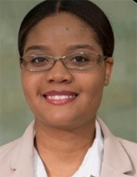
Jocelyn Rajaballey
Academic Background: A.S. Public Health, BMCC (2021); B.S. Urban Health Geography, Lehmann College (2021) and GIS Certificate, Lehmann College (2022)
Update: Currently working at the New York City Emergency Management Department as a City Service Corps member, gathering Community Engagement Data. Prior to that I was a Research Assistant at the CUNY Institute for Health Equity (CIHE). I analyzed spatial and qualitative research data collected by CIHE, creating both static and interactive maps for publication.
Linkedin: https://www.linkedin.com/in/jocelyn-rajaballey/

Jada Grandchamps
Academic Background: A.S. Environmental Science, BMCC (2017); B.A. Environmental Earth Science, City College (2019); M.S. Geography, Hunter College (2021)
Update: Currently a Field Hydrogeologist at PW Grosser. Previously a Research Assistant at CUNY’s Anderson Lab, which conducts biogeographic studies at the interface between ecology and evolution, including spatial patterns of environmental suitability (e.g., for a particular species) and their ecological and evolutionary consequences.
Linkedin: https://www.linkedin.com/in/jada-grandchamps-567a0a141/details/education/
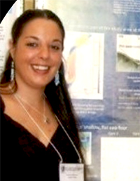
Lisa S. Palmer
Academic Background: A.S. Geographic Information Science, BMCC (Attended 2013 to 2015, transferred to Hunter College); B.A., Geography and GIS, Hunter College (2017)
Update: Currently a Career Advisor in BMCC Computer Information Systems Department via the CUNY Inclusive Economy Initiative. I advise 200 students majoring in computer science, computer information systems, computer network technology and geographic information systems with an end goal of internship, apprenticeship and/or job placement.
This DEI program is named CUNY Inclusive Economy Initiative (CIE). Former Board Member of the NYC Geospatial Information Systems and Mapping Organization (GISMONYC.ORG). I was a recent Guest of Honor of the AFCEA New York chapter President at The 100 Year Association induction of AFCEA International.
Linkedin: www.linkedin.com/in/lspalmer
Any advice for people considering a career in GIS? The number of professionals in this field of spatial data science is very small so start building your network as soon as possible by attending local GIS events.

Pizeme Tchara
Academic Background: A.S. Multimedia Programming/Computer Programming, BMCC (2008); B.A. Communications and Media Studies/Computer Programming, NYU (2012); M.S. Geographic Information Science and Cartography, Lehmann College (2019)
Update:I am working for Federal Emergency Management Agency (FEMA) as Emergency Management Specialist (Recovery) – Geospatial and Data Analyst,
Linkedin: https://www.linkedin.com/in/pizeme/
Did you take any GIS or geography courses at BMCC, or other courses (computer science?) that helped prepare you for studying GIS later on?
I did not take any courses relating to geography at BMCC but I took many classes such as Multimedia Design, Interaction to Design, Programming for Multimedia, and Introduction to Statistics that did ease my learning and proficiency in geospatial analysis, map design, and Python programming within the GIS platform.
What got you interested in pursuing a master’s degree in Geographic Information Science and Cartography at CUNY-Lehman College?
Lehman College has a rigorous GIS program mixed with lectures and hands on trainings (exercises based on real life situations) that prepare and familiarize students with all the components of GIS tools as well as data manipulation and various spatial analysis that one might perform depending on the situation and the subject under study. In addition, the students are allowed to take python programming class which is a great proficiency needed by most GIS professionals, and cartographic design classes that help student in perfecting their maps and producing better cartographic illustrations.
Any advice for students who might be considering studying GIS and pursuing it as a career?
A GIS degree comes with unlimited job opportunities, because most human activities are related or confined to space thus geospatial technology plays an important role in other field of study and professions such as Health, Economy, Demography, etc.
Alexandrea Fortin
Academic Background: A.A. Liberal Arts, BMCC (1998); B.A. English/Geology, Queens College (2010); M.S. Geology and GIS, University of Rhode Island (2013)
Update: I currently work in the environmental science field. This involves construction oversight, taking air samples, performing surveys and writing reports. after BMCC I went on to Queens college to receive a BA in English with a minor in geology (I have the credits for the environmental science minor too, but it wasn’t offered at the time). I then went on to receive a MS in geology and GIS from the University of Rhode Island.
Linkedin: https://www.linkedin.com/in/alexandrea-fortin-b0449720/
How have you used GIS in projects, either at school or work?
For my MS I used a GIS site suitability analysis to locate high pH springs in ophiolite sequences in Northern California.
Any advice for people considering a career in GIS?
GIS is often used in the environmental field. It is also used in demographics, town, state and federal agencies. GIS is what creates the bulk of online maps. If you are interested in pursuing any of these fields, GIS would be an advantage.
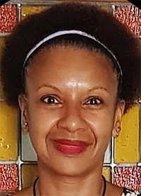
Juanita Corea
Academic Background: A.A. Liberal Arts, BMCC (1989), BSc Oceanography, University of Washington; MSc Geographic Information Science, University of Denver
Update: After 20 years as a defense Geospatial Supervisor and Analyst, I switched to being a full-time student. Currently I’m a PhD student in Geography and Geoinformatics at George Mason University. Previously, as a GIS/Geospatial Engineer, I had over twenty years progressive hands-on experience in military geography, geospatial analysis, cartographic production, geospatial data exploitation, database management;
Linkedin: https://www.linkedin.com/in/juanita-corea-map-lady/http://portfolio.du.edu/Juanita.Corea
Any advice for people considering a career in GIS?
So often I hear undergraduate students say how difficult it is to find their first GIS job, but I think they often don’t realize GIS is a perfect complement to so many other fields: crime analysis, forestry analysis, environmental policy, urban planning, conservation management, natural resources management, transportation planning, disaster or emergency planning, web development, or database management. Don’t limit yourself to only searching for a GIS job but see if another position needs GIS skills to be successful.
As a GIS student, ensure sure you have a good grasp of statistics and at least one programming language (Python or R are the most common in GIS). After you graduate, never stop learning. Take free online courses each year to stay up to date. Remember to network with other people in your field and to join professional organizations, such as URISA. You never know where the next job will come from.
